Preface and Disclaimer: Howdy all! This post is pretty long. It may take a bit for the pictures to load. Give it a few minutes and all the pics should load. If you want to see only the pics, the link is at the bottom. There are a bunch of pics, so click on the link and go eat a sandwich. When you're done, the page should be loaded. Enjoy!
July 7 through July 15, 2006
"I still don't have any service!" the voice said as I looked up the sidewalk. A rather portly girl, staring at her cell phone and dressed in a manner that a portly girl probably shouldn't dress in, was coming towards me. I swerved to one side as she walked by, all the while staring fixedly at the phone. I supressed the urge to turn around, grab her phone, and chunk it off the edge of the Grand Canyon. But it was hard. We were four states, six days, and 13 national parks into our trip through the Southwest.
On July 7, 2006 we left Port Mansfield, TX, headed in the northwest direction. Our very loose itenirary was to go into the Southwest, visiting National Parks as we went. If there was an area in the world that I would say we were well traveled, the Southwest would be it. But when I would look at a map, there were so many interesting places, within just the National Park system, that I could say I'd never been. Since we had time, and a little extra money from our now defunct Trans-Am trip, I wanted to investigate.
Port Mansfield is a coastal town around fifty miles north of Brownsville, TX. To move in our intended direction from Port Mansfield, our asphalt options were fairly limited. We left Port Mansfield and drove across the bottom toe of Texas, meeting up with the Rio Grande at Laredo.
Since we were there last, Laredo has finished a new loop, which makes getting around the town very easy (a prospect we liked!).
From Laredo we had to drive a few miles north on Interstate 35, until we turned northwest towards Eagle Pass. Our only other option was to follow the Rio Grande on a Farm-to-Market road, which eventually turned to an unpaved county road. With the civil unrest in Mexico the way it is, we decided it wasn't a good idea.
We came back to the border again at the town of Eagle Pass and would parallel the river for the next several hours. As we drove along the border towns from Eagle Pass, we began noticing an interesting fact. Being able to compare border towns from Brownsville up the river began to show us the the lower valley, say from Brownsville to Laredo, is becoming prosperous. In fact, we would classify it as prosperous enough to not look like Mexico anymore, unlike a few years ago.
Laredo to Del Rio, however, is still in that cultural, and economic, limbo of not being quite as destitute as being in Mexico, but still being light years from being part of the United States. Most homes, and cars, in this area are still pieced together with whatever is available at the moment. But you still get the idea that the people there are aspiring to become part of the U.S.
By this time we needed a place to stop and make our sandwiches for lunch. A few miles outside of Del Rio, we came to the Amistad Resevoir National Recreation Area Visitor Center. At first glance the building looked like nothing more than a place where the poor park rangers would come to comisurate with each other about how the Park Service had sent them to, seemingly, the ass-end of the National Park galaxy. When we entered the building we were, suprisingly, greeted by a very nice room full of all sorts of information about the Recreation Area.
We cussed and discussed with the Ranger at the desk for a few minutes. I asked him about some of the petroglyphs that I knew were in the park. He told me what he knew, but then told me that he really wasn't the person to be talking to about that type of stuff. Their resident athropologist(yea, I know----how the hell does a place like that get its own anthropologist?) was the real scholar on the subject.
He called into a back room and Kenny Rogers walked into the room(and I'm not talking about "The Gambler" Kenny Rogers; I'm talking about the Kenny Rogers of "Kenny Rogers and the Fifth Dimension" or whatever, right down to the rose colored glasses). Of course it wasn't really him, but it was close enough that I expected him to say, "hello, I just dropped in to see what condition my petroglyph was in."
We talked to Kenny for a few minutes, in which he told us that the petroglyphs in Amistad were mostly older pictographs (the painted kind) dating from before the time of Christ. Most of the "glyphs," as a resident anthropologist would say, were fairly well off the beaten path and only open to visitors on two weekly ranger-led tours.
We watched a video in the Visitor Center Theater(read, room with big screen T.V. with VCR, and in no way am I complaining) describing the petroglyphs in more detail, and left to make our sandwiches.
The highway from Del Rio towards El Paso is littered with interesting towns. There's Langtry, named by the famous, or infamous, Judge Roy Bean, for the actress Lily Langtry. There's Sanderson, a town I only mention here because, as we drove through, I noticed a man mowing rocks in an R.V. park. It had to be rocks because it sure wasn't grass! There's Marathon, a town which the historical markers says reminded somebody of the plains of Marathon.
My favorite town along this line is Alpine. Alpine is a town of around 4000 based on ranching, but with the odd distinction, odd for a town like this, of having a fairly large university, Sul Ross University. So you have a town with the flavor of Lonesome Dove, but with an attitude that's slightly skewed to the college liberal side. It's very rare you can have a liberal cowboy town, but there you go.
From Alpine we turned north. If we'd wanted to, we could've traveled west a few more miles and seen the famous Marfa lights, but we were wanting to go to Fort Davis National Monument, so north we went. We arrived at the town of Fort Davis late in the day and found a camping spot at Fort Davis State Park. The evening was highlighted by seeing several Montezuma Quail with their golf-ball sized brood. The night was lowlighted by a family of, I think, 47, staying up until way past midnight, becoming drunker, and louder, by the hours. We left at 7:30 A.M. in order to be at Fort Davis National Monument at 8 A.M.
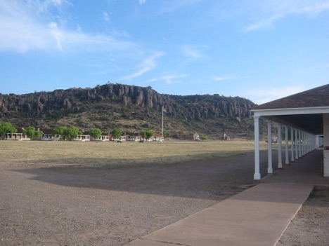
visitor center explained that LBJ had made the Fort part of the National Park system (dedicated in person by Lady Bird herself), and we were betting that he was able to provide plenty of financial help.
The fort itself is the standard fare of restored buildings with soldiers' effects within some of the buildings. The P.A. system would play the bugler's call at the time that a real bugler would've, when the post was operational. I know that it was supposed to add the realistic-ness of the fort, but it was as annoying as hell. It seemed that every five minutes another bugler was blowing away.
As we walked through the visitor center, we noticed that several of the artifacts from the fort were missing. A sheet attached to the glass where the artifacts once were, explained that, earlier in the year, the visitor center was burglarized and the artifacts (mostly 19th century firearms) that lived behind the glass were stolen. It went on to explain that the burglars were caught a few months later, in one of the Carolinas, after no less than eight police agencies, including the Brewster County Sheriff's Department, the Texas Rangers, the ATF, and the FBI, were on the case. Committing a crime on federal land, in Texas, creates an interesting situation where law enforcement is involved, especially when the crime is stealing a firearm.
After a short walk around the grounds(I mean, let's face it, there's only so much that can take up your time at a restored military post), we were back on the road headed north to Balmorhea State Park in Balmorhea, TX. This trip to Balmorhea would be our third.
Located within the state park is San Salomon Springs. Sitting here trying to come up with a way to describe how other-worldly the Springs are, relative to their surroundings, is hard. I'll give the facts and you draw the picture in your head.
The springs lie at the northern end of the desert mountains of West Texas. The vegetation consists of cactus hanging on to gray-brown dirt.
The spring has an output of one million gallons per hour(this is no typo).
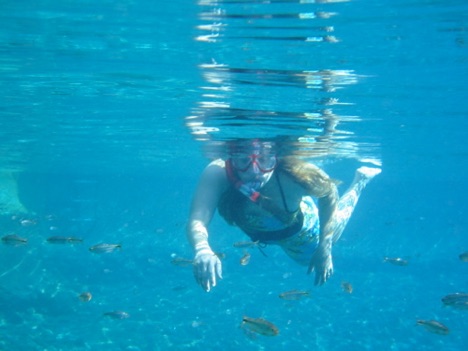
The pool is amazing in itself. The circular portion has a ledge around the edge approximately four feet deep, but the from that, the depth drops to as much as 25 feet in the middle. The bottom is lined with rock and all manner of fish, mostly different types of minnows with a few catfish, and turtles abound in the water. With good goggles and a snorkel we both could spend hours just floating and watching stuff swim beneath us.
One of the offshoots from the circle has a concrete lined bottom and is four feet deep throughout. The other offshoot is rock bottom like the circle, but contains a couple of diving boards.
We arrived around 9 A.M. prepared for a large crowd, since it was a Saturday, and were pleasantly suprised to find the place fairly deserted. We immediatly grabbed our snorkels and masks and were in.
The water is amazingly blue, and each time we go I still find myself commenting on the clarity. It's easy to see the bottom. The temperature ranges in from 72 to 74 degrees.
We floated and watched and floated and watched. Several scuba divers were on the bottom and we'd go over and float in the bubbles they would create. The sensation is unique.
After 30 or 40 minutes, the crowds started to descend, and we decided to head on down the road.
We headed west on Interstate 10 for El Paso. We knew of several places we wanted to go within the city, namely a church our map called the oldest in the state and Chamizal National Memorial.
As we approached the city a sign told us that if we turned off the interstate towards the river we could drive the "missions trail." We looked at each other and said, "why not?"
I said earlier that the lower Rio Grande Valley, around Brownsville, is becoming prosperous. I also said that the cities from Laredo to Del Rio, along the river, were much poorer, but trying to become part of the U.S. When we turned off Interstate 10 to drive the "missions trail," it was obvious that El Paso and its surroundings are still part of Mexico, no matter what side of the river they are on. When you look across the river, the buildings and surroundings are only marginally worse than from where you sit. The people don't seem to be concerned with the trappings of life in the U.S. Most signs are in Spanish first, and then, if they felt like it, they made another sign in English.
When we left I-10 we were maybe 20 miles from El Paso proper. We drove to the river and then paralleled it into El Paso. Along the way we saw several missions from the 19th century, all of which retained the look of the time period they were constructed, but were still in use. Two of these missions were originally built in Mexico, but a major flood that changed the course of the river in the early 20th century left them on US soil--weird to contemplate.
The most disturbing "highlight" of the mission tour was in a side room that housed the church's figurine of a crucified Jesus, made from wood. The figure was almost life size and encased in glass. The case was made with wood handles at each end so the case could be picked up and paraded down the streets to scare anyone under the age of, say, 30, mainly because it scared the shit out of us.
Almost into El Paso proper we came to the Tewa Indian Reservation. If not for a sign telling us we were on the Reservation, we would've never distinguished the Reservation from the city. Neither of us had ever heard of any Reservation around El Paso, and here was one practically in the city.
We looked at the mission established for the Indians who left New Mexico during the pueblo revolts of 1680. The other mission buildings weren't that old, but the church was. The pueblo influence was still noticable in the rugs, featuring images of corn, hung on the mission walls.
From that point we had a decision to either get back on I-10 to go into town, or follow lesser streets on into the city. The interstate was fairly far away, and since neither of us had ever been off the interstate in the city, we decided to take the city streets. Chamizal National Memorial was our destination.
Twenty minutes later we were still looking. After a while, I became exasperated, not suprisingly. By that time, I think we had made a big circle. At one point we made a left turn onto a freeway and immediately ran under a sign welcoming us to Juarez, Mexico. After swerving across eight lanes of traffic, pulling a U-turn, swearing profusely back at the people swearing at me, and swerving back across four more lanes of traffic, we arrived at Chamizal.
For those of you asking, "what the hell is Chamizal National Memorial?", let me explain.
After the Mexican-American War in 1848, the two governments decided that the Rio Grande would be the boundry. Only problem was the river moved, sometimes overnight if it flooded, or very slowly sometimes. The governments decided that if the river moved slowly, then the middle of the river would always be the boundry. Unfortunately, they made no provisions for when it flooded.
In the early 20th Century, if I remember correctly, the river flooded. The river shifted a great distance to the south. Almost overnight, 5000 Mexican citizens found themselves living on the north side of the river.
Since they were now on the north side of the river, the land they owned was now in America. And, being the great Americans that we were, the U.S. said, "the land is American, get off and go back to Mexico."
Naturally, the Mexicans didn't see any reason they should leave the land they owned. Both governments kinda stood around and shrugged their shoulders and told the dispossesed, "tough titties." As long as the people weren't in open warfare, the governments seemed to not care. The disputed territory became known as the Chamizal.
The situation festered for almost half a century. In the early 1960's, JFK actively sought a diplomatic solution to the Chamizal, mostly because residents of the area were looking at Castro as a champion of the dispossesed. He went to Mexico City several times. Finally, in the late 60's, LBJ and Mexico's president came to an agreement that entailed splitting the Chamizal in half. Mexico would keep half and the U.S. would keep half.
To split it, they would move the river to the middle of the Chamizal. They would concrete-line the river through the city so it would never shift again. Each nation split the cost.
The land where Chamizal National Memorial sits is the U.S. portion. It has a good visitor center with a 500 seat theater, and includes maybe 30 acres of parks and ballfields. The Mexican portion has a memorial in the same fashion. The idea is to use the area as a cultural center and to commemorate the peaceful settlement of an international dispute--a nice idea.
It was very interesting to go there and see a part of history that, as far as I could tell, is just about completely forgotten. I had always wondered why the river was concrete-lined in the city. Now I know.
We spent a half hour perusing the Memorial and jumped back onto I-10 headed west. We spent the night in Lordsburg, NM, a one horse town the horse left 30 years ago.
The next morning we turned southwest. Our immediate objective was to find the marker where Geronimo had
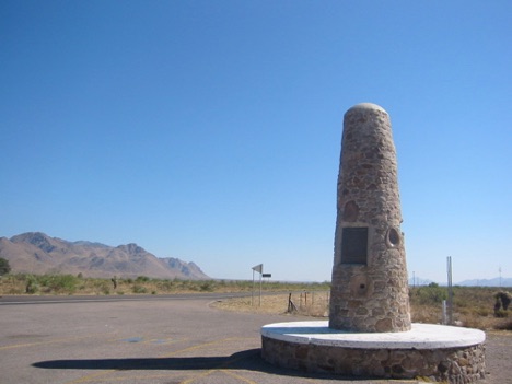
To say that it wasn't exactly what I expected was an understatement. Since there is a picture here I won't try to describe it. To be honest, I was expecting nothing more than a historical marker.
I knew that the marker wasn't the actual place where Geronimo had surrendered. I had seen on the map that it was several miles down a county road to the southeast.
I was deteremined to stand on the exact spot, so off we went. Unfortunately, immediately after turning onto the county road, we were blocked by a gate proclaiming that the road was closed. Darn it all! I guess I would have to be happy with a penis-shaped rock structure telling me that I was at least close.
No problem. We had plenty of other places to be.
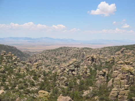
The Chirachaua Mountains' ecosystem is an anomoly. In the very distant past, the climate around the mountains was much cooler and wetter. This allowed many species of animals, like the coatimundi, to come into the mountains. The climate changed and the surrounding areas became desert. This acted like a fence around the mountains and held the species in the upper elevations. So the Chirachaua Monument is special, if for nothing more than the place where you can see, if you're lucky, some rare species that shouldn't exist in that area.
It's also special for its amazing rock formations. Spires of rock, reaching 40 to 50 feet high, abound in the upper elevations of the mountains, giving the landscape an eerie feeling. We stayed for a while and drove to the top of the mountain to see the views. We ate our lunch with the view you see above.
Back on the road, we had a choice to make. We could either turn northwest towards Tucson and go north from there. Or we could spend an extra half day by going southwest towards Nogales, AZ, right on the border, to see another Spanish colonial mission built in the 18th Century. We spent a while deciding if the mission would be worth the extra time and money. In the end, we figured we were on this trip to see what we could see with our available resources, and we had the resources. So, we went for it.
And of course one of the deciding factors in our choice to take the longer route was helped by the fact that the longer course would take us through the famous Tombstone, AZ! Actually I'm kidding about it being a factor. We weren't excited, but mildly intersted to see if the town would live up to all our expectations, which were that it was going to be a town living on its popular past, and in the process creating a carnival-like atmosphere that probably didn't reflect what the town was actually like at the time it was trying to recreate.
Let me tell you, Tombstone didn't let us down in any way, shape, or form.
When we arrived in town, nothing jumped out at us. It looked like a normal town for the most part. We literally were going to drive through the town without noticing anything out of the ordinary, except for one sign desinating where the O.K. Corral was.
"That's odd," I thought.
I decided, out of morbid curiosity to turn onto what I thought was a side street to see if that was really all to the town. Boy, how I was wrong! One block from the highway was the "mainstreet" of Tombstone.
First off, the "main street" was still dirt. Actually, I've got a sneaking feeling that it was asphalt with dirt brought in
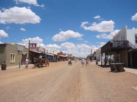
The main street was blocked from auto traffic. I think it was only legal to either mosey, saunter, or shuffle down the street without being thrown into the "pokey."
To my shock, Meredith said that we must park and at least walk a little down the street. I picked my jaw off the floor board and found the nearest parking space that I could.
Now, I don't know why exactly I'm suprised about this, but it's impossible to actually go in the O.K. Corral without paying $8, which seems a bit absurd since we could stand on the sidewalk right outside the wall and hear the record, recreating the happenings, they played for the poor saps that paid the money to go in and sit. And, oh what high drama was transpiring inside. The dialog made John Wayne seem Shakespearean. ("No! I don't want to die." inflected in the style of a third-rate junior high one act play.) I was just dying to hear the scratchy recording proclaim, "Boy, I'm going to tear down your meat house", a la Louise L'Amour.
As we walked down the sidewalk we noticed people in period costume just kinda standing around acosting people, trying to make them feel like they were really in the Old West.
For an ungodly amount of money, we could have taken a ride in real live stage coach. The only catch was it wasn't too real live since there was a man walking around with a poo shovel scooping up the horse poop whenever the horses let loose. Apparently, its fine to act Old West, but they draw a line when the shit actually hits the ground. Also the stage driver was narrating the trip using a Madonna-like microphone--very authentic.
Needless to say, we made it maybe 50 yards down the street before we bailed.
There have been many times in my life when I was grateful for forcing myself to do something. Late in the day we arrived at Tumacacori National Monument. To this moment, I still thank myself for making the decision to go.
First off, Tumacacori is pronounced Tuma-cock-ory. Tumacacori is one of many missions built by Spanish missionaries in Arizona.
What makes Tumacacori different from other missions is that the National Park Service is its steward, it's in fairly good shape, and it's open to the public.
In the 1700's, the Apache Indians were a constant threat to the Pima Indians of what would become southern Arizona. The Pimas heard about the men in black robes to the south, and, uncharacteristically for Indians, sought the Jesuits Priests out. They asked the priests to come a build a mission to help protect them from the Apaches, and provide them with new crops (especially fruit trees) and cattle.
The original mission that was built does not remain. The second mission, built in the late 1700's, does, along with
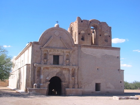
The park service allows people to walk into it. The original ceiling over the years was dismantled and used for different things, like firewood and house repair. The interesting sight inside is looking at the orginal painting on the walls. In a side room, people who have passed through have etched their name. The Park Service said that "Black Jack" Pershing had etched his name somewhere in that room, although were never able to find it.
I have to say that by the end of time I was really glad that I made myself to go see it. It was an amazing building to see, mostly since it was in its original state and not like the Alamo or the missions we had seen earlier in the trip. We felt grateful. Also, it's just amazing to see how long was the arm of Spanish Catholicism. There are literally dozens of missions in the area. As you walked around you couldn't help but wonder how it felt to be a Spanish priest, born in Seville, educated in Rome, saying mass under a brush arbor while directing the construction of the church.
By the time we were done, it was late in the evening and we went north to Tucson to find a room for the night. Interestingly, the Interstate on the way to Tucson had distance markers in metric only. We've seen metric markers along with mile markers, but never only metric. We assumed that, since that Interstate began at the Mexican border, the builders were just assuming only Mexicans would drive on the Interstate.
Tucson was a fairly unassuming town. It's hard to be too assuming when it's 115 degrees.
We got up the next morning and headed west to Saguaro National Monument, the home of the world famous Saguaro Cactus. If you think you can't picture a Saguaro Cactus, yes you can. When I say cactus, you picture a cactus in your head. I'm willing to bet you pictured a Saguaro.
The Saguaro is the cactus with the arms extending out and up.
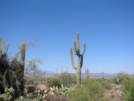
They do not start growing "arms" until they are at least 75 years old.
They regularly live to 200 years old.
They have what looks like a wood skeleton.
The Visitor Center was brand new, and we spent a while watching the video in their theater. Then we took a drive around a loop for a few miles and did a short walk to see a few petroglyphs. Along the way, we saw a lizard the size of a squirrel and were very scared.
Once the temperature was over 110, we decided it was time to move on.
We headed up Interstate 10 towards Phoenix. Halfway between Tucson and Phoenix, we turned north to go see Casa Grande National Monument.
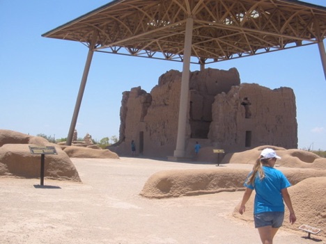
The ruins at the monument are interesting for a couple of reasons. First off, the ruins contain no rocks, like other ruins. They are constructed of mud and look like regular adobe.
Since they are made of mud, they deteriorate rapidly. Early in the 1900's, the Park Service decided to help slow the deterioration by building a huge canopy for the the main building. It really gives the ruins a different look, to say the least.
The main building is very large. It has three stories, and, since its condition isn't the greatest, even with the roof, they won't let anybody in it.
Casa Grande is one those places that all you can really do is stand there and say, "yep, there it is." But it was interesting, none the less, and the displays in the visitor center were fantastic, showcasing artifacts found in the ruin. Many of the better-known ruins were excavated by groups sponsored by the Smithsonian, the National Geographic, or a major university. As a result, most of the local artifacts are on display in Washington, or worse yet, are gathering dust in a back room somewhere.
We moved north from Casa Grande, through several towns, and climbed a thousand feet in elevation. About mid-afternoon we came to the Theodore Roosevelt Resovoir. We would find out later on that the lake was built in 1901, which shocked the fire out of us. Neither of us thought there were enough people in Arizona that early to build anything that large, especially in that part of Arizona. The lake is surrounded by desert mountains that rise several thousand feet. Up in a crevice of these mountains is Tonto National Monument.
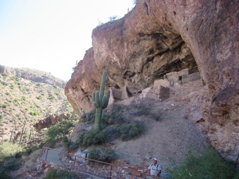
The ruin itself isn't particularly spectacular until you sit and and look back down into the valley where the lake now sits and imagine having to walk down to do anything in life, and then having to walk back up carrying all supplies you'd need to live.
In certain areas the Park Service will place rangers to keep an eye on people and help them with any questions the visitors might have. When we arrived at the ruin, a family of seven or eight were finishing their visit and starting back down. We were the only ones in the ruin and were able to talk rather casually with the ranger. We kinda chit-chatted for a while, looked around, and decided to head back down.
We had both noticed that the ranger was holding a counter, obviously for counting the number of visitors that came to the ruin. Meredith asked her how many visitors they'd had on that specific day.
"Um, you two were number 15 and 16 for the day," she said.
We both expressed our suprise at the low number.
She said the number of visitors fell sharply after 9/11 and hasn't risen back to pre-9/11 levels. We again expressed suprise. We thanked her and started back down.
Back in the car, we drove north to the town of Camp Verde, just south of Flagstaff. The next morning our first stop was Montezuma Castle National Monument. Another indian ruin(yes we have a thing for ruins!), this was also a cliff dwelling. This dwelling isn't accessible to the ordinary park visitor. We had to sit and look from a distance.
Within the park is another sight that neither of us had ever seen. It's called Montezuma's Well. By the way, Montezuma was never near any of these places. The early archeologists thought they were built by the Aztecs. So they named it after Montezuma, unfortunately.

The sight is amazing, to say the least. (In the top left of the picture, you can see a small room block with attached granary.)
Meredith and I were standing in amazement when a female voice, with a very Jewish, New Jersey, accent, to our left yelled, "Look, look, a turtle!"all the while pointing feverishly, her jowls quivering with excitement.
I looked over to see a family of four. The two boys looked to be 15 and 17 respectively, and very, very sad (and slightly Mongoloid).
The dad, wearing the best Gilligan hat I'd ever seen, grabbed the camera hanging around his neck and started snapping away at the turtle bobbing in the water no closer than 200 feet. They pointed and gawked at the turtle for at least a minute, all the while, making absolutely as much noise as possible.
After another minute or two, they walked on down the sidewalk. Meredith and I enjoyed the silence.
We followed the sidewalk down into the well. It took us to the area where the water from the well goes into a crevice in the rock and exits the well. The area is very green for obvious reasons and the air was cool.
"Oh, my god! A lizard!"
I looked up to see our neighbors from earlier. The woman was standing stone still, pointing at a lizard that had run across her path. The husband was faithfully snapping away at the 2 inch long lizard that was 12 feet away.
After a minute she quit pointing and went back to asking her husband exactly what was special about this place he had brought them to. He kinda mumbled incoherently. It didn't matter anyway since she'd already spotted another lizard and was yelling and screaming.
By this time Meredith and I were enraptured. This was better than television and, not given any other option, followed them down the sidewalk, well within hearing distance.
"Now what is this place called?" she cackled.
"Montezuma's Well," he said.
"Well, it's tons better than that Hopi House that was way out in the freakin' middle of nowhere," she said.
Meredith had to stop me from going over and asking her to give me detailed information on how to get to "the freakin' middle of nowhere", because I was ready to go there.
"Another lizard!" she yelled.
The husband ran over and started taking pictures.
"My god, how many pictures are you going to take of a lizard?"she asked and started walking away.
He just bowed his head and followed.
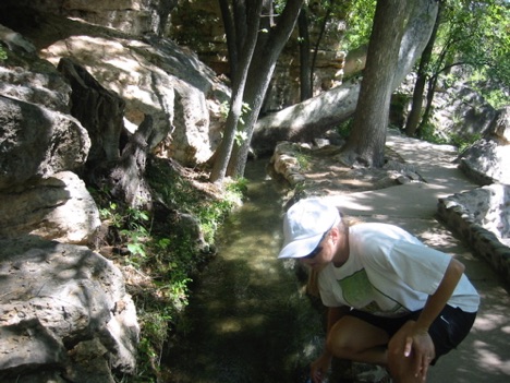
After enjoying the well, we moved on. A park ranger at an earlier park had told us to not take the interstate into Flagstaff and instead take a side road through Sedona, AZ into Flagstaff.
The land around Sedona is redrock to the extreme. As soon as we got close to Sedona the land changed from limestone to blood red chunks and spires. The town itself is very highbrow, sort of an Aspen of the desert. Tour buses and women wearing wearing cowboy hats while shopping seemed to be the order of the day. So, we kept right on driving.
Next up was a trio of National Monuments: Walnut Canyon, Sunset Crater, and Wupatki.
Walnut Canyon and Wupatki were, once again, indian ruins. The highlight of both parks was the "blowhole" at Wupatki.
The blowhole is nothing more than a hole in the ground--only this hole is connected to very deep underground passageways. The caves are deep enough to be affected by air pressure. Consequently, if the barometric pressure is rising, air is forced into the blowhole. So, the hole actually sucks in. On the Alaska trip, the hole was sucking.
This trip the pressure was falling, so the hole was blowing. The outside temperature was pushing 100 degrees, but the hole was blowing air around 70 degrees. It felt like standing over a very large air conditioning duct. It was hard to leave.
Wupatki is near another amazing geological feature--Sunset Crater. In the 1060's, from nothing, the ground cracked. Lava and ash started spewing from the crack. Within a few days, a cone started to form from the ash and pumice. Within a few years, that cone had risen to over 1000 feet.
Once the smoke had cleared, a cone of pumice was left standing where, previously, nothing was there. That cone is now known as Sunset Crater. It's quite shocking to think about.
By the time we were done with all three monuments, it was fairly late in the day. We had enough time to make it to the Grand Canyon, but probably be able to do nothing more than drive to the edge. We decided we'd like a little more time at the Canyon. So we drove back to Flagstaff for the night.
The next morning we left early so maybe we could beat a few of the people. We drove the 60 or 70 miles to the west entrance of the the south side of the Canyon. We passed several towns along the way that were only there because of the park. In one town, there was an IMAX theater showing a film about the Canyon. We decided to pass since time was a-wasting and the tour buses were descending.
Around 1541, a detachment of Coronado's expedition, led by the Hopi indians, came to the southeast edge of the Canyon. The Spainiards must have thought the Hopis were leading them to nothing because when you approach from the south, the land gives no clues of anything you may be approaching. The elevation is around 6000', and Ponderosa Pine are the dominate tree. The land rises and falls gently.
Past the gate, which has three inbound and three outbound lanes, you still have to drive six more miles before you come to the edge.
The night before, we read a few "tips" the Canyon website provided. It said there were several ways to get to the visitor center. You could either park in the parking lot by the edge and take the shuttle to the visitor center. YUK! Or, you could park in the parking lot by the edge and walk 300 yards to the visitor center! Interesting. We decided we could make the 300 yards of walking before we collapsed.
Shockingly, when we arrived at the edge, there were several parking spaces left in the 300 space lot. To be fair, this parking lot is the first lot anybody comes to when they arrive at the edge. In reality we would drive most of the length of the Canyon during the next several hours and have plenty of room. Most of the smaller lots rarely had more than a few cars.
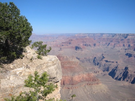
We walked the demanding 300 yard sidewalk to the Visitor Center, which reminded me of an outlet mall. We kinda browsed for a few minutes and walked another 300 yards back. By this time we'd walked over 600 yards and were tired(I hope my sarcasm is thick enough). So we got back in the car and started driving along the edge. Every so often there was a lookout.
In one area, a ranger station, built in the 20's, had been converted to a viewing area with one wall being entirely glass. It made a very interesting viewpoint.
We stood and stared for the prerequisite amount of time and then moved on.
We drove and stopped and drove and stopped for the next several hours, each time staring into the crevice and saying, "wow, it's deep."
By lunch we were at the eastern edge, and back at a larger parking lot with more people. On our walk back to the car for the last time, we had our encounter with the girl and her cell phone problems. We figured it was time to leave, so off we went.
We drove northeast from the Grand Canyon. Fairly quickly we entered the Navajo Reservation. The Navajo Reservation is the largest reservation in the nation. We drove through the towns of Tuba City and came to Navajo National Monument.
Navajo National Monument is only connected with the Navajos because it's on the Reservation. The ruins are all Anasazi. Unfortunately, the hike to the closest ruin is five miles roundtrip. A ranger led trip leaves twice a day in the summer, but we had missed the last one. So we were left to walking to several overlooks to see the ruins from a distance. The ruins were immaculate, and we decided that we must go back and hike to the ruins.
We drove on down the road, setting our sights on Bluff, Utah for the night. We drove through Monument Valley, my first time all the way through, and arrived at Bluff around 5 P.M.
Our objective for the next day was to drive northwest towards Lake Powell National Recreaction Area and ride the ferry across the lake. We wanted to see if the lake was as pretty as we had seen and heard.
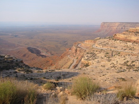
When you arrive at the base, you see that the road is "dug" into the side of the cliff, and starts snaking up the side of the cliff. The road changes to gravel. You climb and climb up numerous switchbacks and finally reach the top. The view is great from the top. Back to the southwest, you can see Monument Valley.
The road switches back to asphalt, and you are on your way to Lake Powell.
Lake Powell is from another universe. Half a decade ago, the people of Phoenix and Las Vegas decided they really liked having swimming pools since the temperature was over 100 degrees so often. Also, with the influx of people, the water demand soared. The Army Corps of Engineers decided they would dam the Colorado River above the Grand Canyon and fill Glen Canyon. Only problem was that Glen Canyon was littered with Anasazi ruins in just about every nook and cranny that archeologists looked.
The Corps announced their plans to fill the canyon in the 50's. Archeologists started trying to at least document where all the ruins were located before the resovoir was full, even as the water was creeping up the sides of the Canyon. In the end, all the scientists were able to do was mark where most of the major sites were before the lake was full. Environmentalists point to Glen Canyon first when asked for the most heinous acts of the government in the mid-century. It does have one upside though--without the outcry over Lake Powell, there would probably be a high dam and a huge resevoir in the Grand Canyon. Hard to believe, but those plans were in the works when Lake Powell was built.
Driving toward the lake from the south is akin to driving to the Grand Canyon from the south, you never expect to see what you're about to see, especially judging from the land. You drive and drive and drive and see sand dunes and redrock and desert. You may not meet a car for 60 to 70 miles and see nothing more than a few lizards. Then,
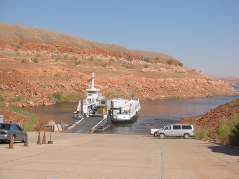
The highway ends at the lake. Actually, the highway doesn't end. The asphalt ends. A ferry carries traffic back and forth across the lake, where the asphalt continues. The ride takes around 30 minutes.
We came to the loading point and the ferry was pulling up to the loading ramp. It off-loaded the vehicles from across the lake, and we drove on. There were maybe 6 vehicles, including a Mack truck with trailer.
We spent the next 30 minutes sitting on the deck of the ferry watching the numerous houseboats on the lake and admiring the very clear water, and saying to ourselves we must come back.
We off-loaded, and were on our way.
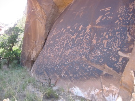
We drove for a few hours towards the town in Green River, UT. The Trans-Am Trail comes through Green River and I had found a few places on the Trail where we could see petroglyphs. So, we went looking for those. We found several nice "glyphs" on the Trans-Am trail and went to Green River to spend the night.
The next morning we headed southeast towards Arches National Monument. When you see a picture of natural arches, they usually come from Arches. Delicate Arch is possibly the most famous arch in the world, and we were excited to see it.
We pulled into the park and browsed through the visitor center for a bit. As we started our drive through the park, the traffic was fairly heavy. Most of the arches require a walk, and there were enough people to make the walks not enjoyable. So we drove through the park looking at most arches from a distance. Unfortuantley, photographs of arches from a distance don't look good. So you'll have to use your imagination here.
We ate lunch at a nearby campground, and headed for Colorado.
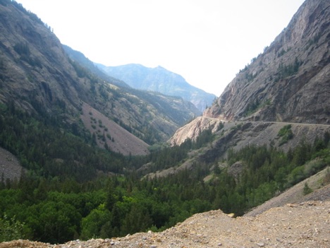
Late in the afternoon, we started rising in elevation. Our intention was to drive the so called "Million Dollar Highway". The name derives from the fact that the gravel used to build the base for the road came from mine tailings. Later tests of the gravel showed it to have trace amounts of gold, leading to speculation that there is a million dollars in the road.
Nevertheless, the road begins in Ouray, CO(pronounced ooo-ray),in the north, and ends in Silverton, CO, in the south. Leaving Ouray, the road switches back and forth severly, while rising 700-800 feet. Also, as the road rises, a sign says this road tranverses the "Alps of Colorado."
We spent the night in Durango, CO. The next day we made the distance from Durango to our trailer in the Moreno Valley, NM.
So, five states, nine days, 2500 miles, and 16 national parks later, we arrived. We've spent the week riding and hanging out. It's been fun writing about our travels, and I hope you've enjoy reading them.
See you down the trail!
